PALEOSEISQUAKE Project
Background
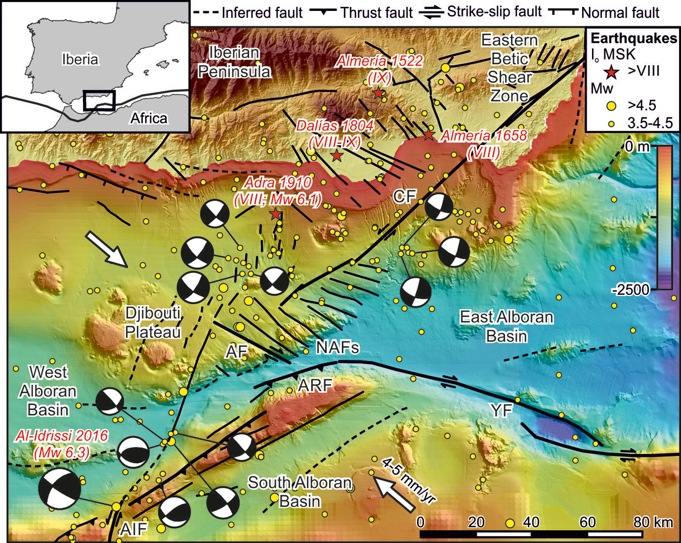
The study of past earthquakes is essential in modern seismic hazard assessment. Seismicity models have been traditionally based on archaeological, historical and instrumental seismicity records. However, in the last decades the fast advance of paleoseismology has significantly improved those models, since it allows characterizing past earthquakes and determining the seismic potential of the source faults based on the interpretation of the geological record. Thus, the strength of paleoseismology is that it covers much longer time periods than the other records. Initially developed for the study of faults on land, in the last few years the paleoseismological concepts are being increasingly exported to underwater areas. Considering that large earthquakes and tsunamis are generated along offshore faults, subaqueous paleoseismology has great potential to a better assessment of hazard in seriously threaten and populated coastal areas.
Subaqueous paleoseismological studies merge and integrate two well-established disciplines, paleoseismology and marine geology, to detect and describe the occurrence of paleoearthquakes on faults located underwater. Since the 2004 Sumatra and 2010 Japan earthquakes and tsunamis there has been increasing interest to improve the knowledge about underwater active faults and estimate the parameters that describe their seismic cycle. Despite that traditional on land paleoseismological techniques are not feasible in underwater environments, subaqueous paleoseismology has several advantages2: 1) fault morphology and segmentation are well expressed underwater, as erosion is minimized; 2) marine sedimentation is generally continuous in time and space, allowing regional stratigraphic correlations; 3) seafloor mapping and sub-seafloor seismic imaging allow exploring extensive areas in relatively short time; and 4) underwater regions are essentially free of human modification. Moreover, subaqueous paleoseismology is benefiting from the most advanced technologies in marine geosciences covering different scales of resolution. Fault exploration methods of active regions from research vessels allow identifying the geomorphic evidence of active faults and seismo-stratigraphic evidence of past seismic activity.
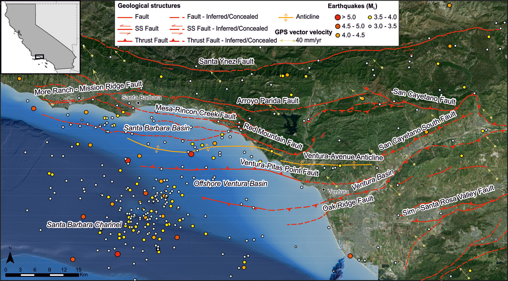
Turbidite paleoseismology is based on the identification and dating of earthquake-triggered landslides and turbidite deposits to obtain the recurrence rate of large magnitude (Mw > 6) earthquakes occurred in a given region. However, it generally do not provide the same degree of observation detail as the current paleoseismological techniques used on land, such as trenching. A way around this limitation is offered by the use of leading-edge technology (e.g., remotely operated vehicles –ROV-, autonomous underwater vehicles –AUV-, or high-resolution seismic systems) to obtain, for example, cm-microbathymetry or sub-metric seismic imaging. With this level of resolution, it is possible to identify young earthquake ruptures, to recognize and date individual event horizons and to obtain vertical slip components for specific events. Recent studies have identified active fault growth sequences on high‐resolution seismic profiles that have allowed to derive the submarine paleoearthquake records directly on-fault. However, they are obtaining just the vertical slip per event and recent vertical slip rate, even though they acknowledge the existence of a probable strike-slip component. Slip-rates are intimately linked with the recurrence period of faults and, thus, they are very good indicators of their seismic potential. Nevertheless, Quaternary net slip-rate calculations usually involve high uncertainties owing to the scarcity of quantifiable strike-slip offset values across faults. The next step now in subaqueous paleoseismology is to move towards obtain net displacements per event and Quaternary net slip rates on faults. The aim of PALEOSEISQUAKE is to recognizing single events and measuring their net displacements in 3D geological models to give more accuracy and quality to the calculation of the Quaternary net slip rates, advance in the understanding of the seismic behavior, and reduce the uncertainties related to this kind of data. These data will contribute to a better understanding and quantification of the seismic cycle of underwater active faults and will help scientists, engineers and civil protection authorities to improve the seismic hazard assessments studies and the earthquake action plans.
PALEOSEISQUAKE project
Hypothesis
Objectives
In relation to the consecution of the main objectives other secondary objectives will be attained:
SO1) obtain the 3D geometry and segmentation model of faults and seismo-stratigraphic units.
SO2) estimate the parameters that describe the seismic potential of the faults (maximum magnitude, recurrence period, slip rate, displacement per event, and elapsed time since the last event).
SO3) determine the tsunamigenic potential of the active faults and recent and buried submarine landslides.

This project has received funding from the European Union's horizon 2020 research and innovation programme under the Marie Sklodowska-Curie Grant Agreement No 6657769